Gradsko setaliste bb, 32000 Cacak
+381 32 342 360
The city of Čačak is located in the central part of central Serbia in the Moravički District. It lies 150 kilometeres south of Belgrade, and in addition to Čačak, the district also includes Gornji Milanovac, Ivanjica, Lučani and Guča.
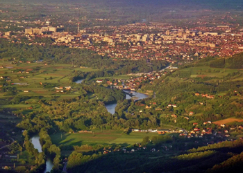
Located mostly in the western Pomoravlje region, the city of Čačak forms a link between the rolling hills of Šumadija in the north and the hilly and mountainous areas of the inner Dinarides in the south. The central part of the city occupies the Čačak Valley, located between the mountains of Jelica in the south, Ovčar and Kablar in the west and Vujan in the north, while in the east it opens up to the adjacent Kraljevo Valley. The surrounding mountains create a landscape with gentle and undulating descent towards the Čačak Valley, the city of Čačak and the course of the West Morava River.
The city territory covers an area of 636 km2, and in terms of relief it can be divided into: -The Čačak Valley with an altitude of 200 m to 300 m -Hilly area from 300 m to 500 m above sea level -Mountainous area from 300 m to 985 m above sea level.
The mountains of Jelica (929 m), Ovčar (985 m), Kablar
(885 m), and Vujan (857 m) surround the Čačak valley,
intersected by the watercourse of the West Morava river,
with a total length of 318 km.
-The valley it is about 40 km long and provides excellent
conditions for agriculture. It total area is over 270 square
kilometers.